- CCT Public Page
- [CCT Members Area]
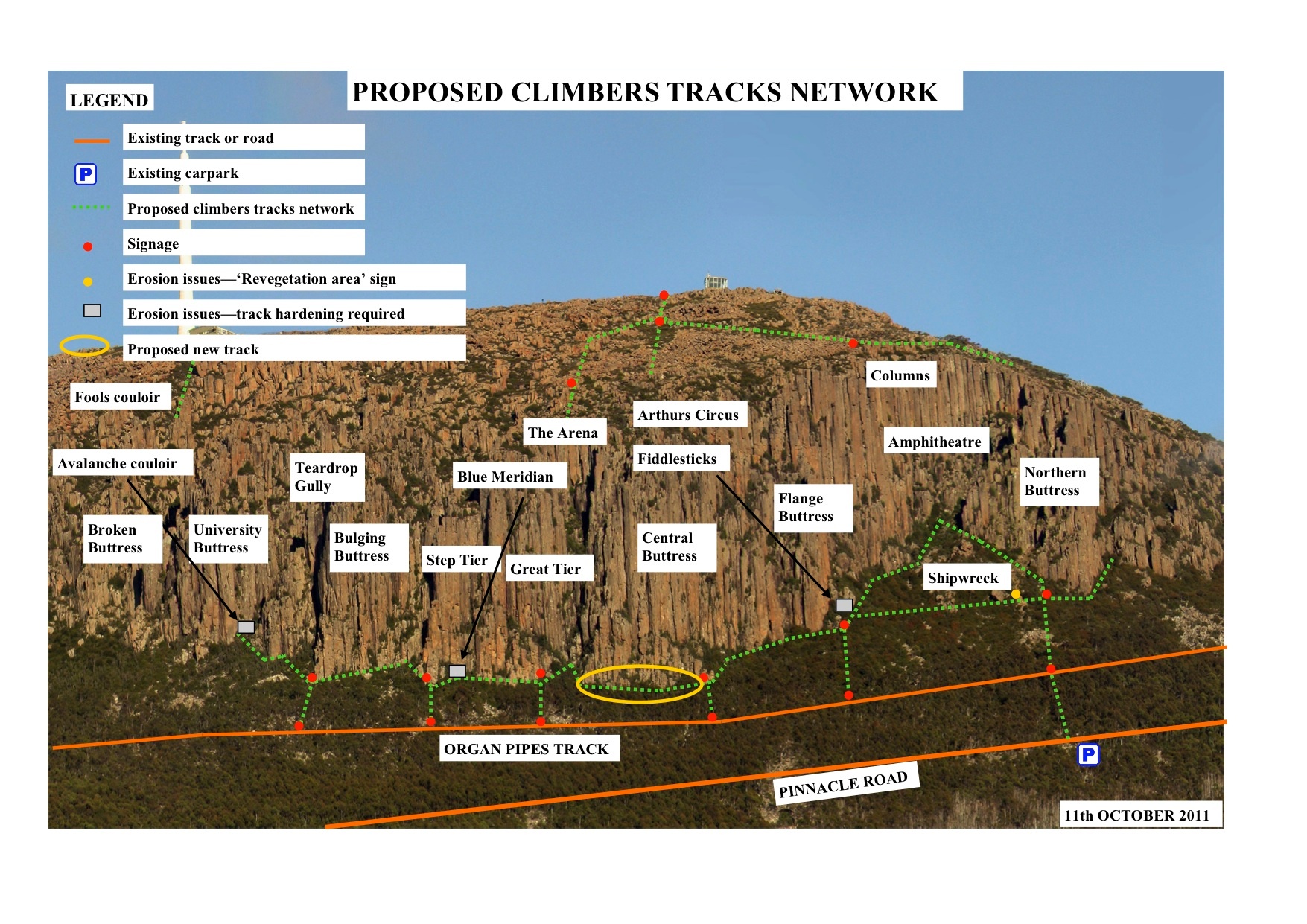
Tony, Phil and I have been working with the Council to provide improved facilities for climbers to the Organ Pipes in Wellington Park. The objective of this work is achieve the following outcomes:
- Formalise a network of tracks to the base of the Pipes and to abseil points above
- Install signage to assist Emergency Services in locating injured climbers
- Mark routes over rocky areas to reduce the number of informal tracks being formed
- Manage erosion issues at the base of some of the climbs
The map attached details what the Council is proposing to do. Most of the tracks are already there, so the work will mostly involve marking tracks by gluing reflective orange markers on rocks, closing off duplicate tracks, managing any erosion issues at the base of some climbs by building steps and platforms with local rock, pruning vegetation and installing small plastic posts with signs to the main buttresses and abseil points.
The Council would like to hear our thoughts on this proposal. Please write your thoughts down as all comments will be considered to ensure that an adequate track system is produced and managed from here on. Please provide comment by the end of Monday 31st October, then we’ll send in all of our comments to the Council.
Doug Bruce
Overview
Content Tools
22 Comments
Jon Nermut
I think that the formalisation of the tracks will reduce overall impact by reducing braided trails and erosion.
The key thing is to make sure that there are just enough tracks that people dont feel the need to bash up anywhere. Its hard to tell, but maybe people might still head straight up to Avalanche Couloir without a dedicated track - but on the other hand people may not bother.
Discretely signed tracks will certainly make it easier to find the buttresses not only for visitors, but also less experienced local climbers.
I think its important that we are very actively engaged during construction.
Btw Blue Meridian is marked in the wrong place. Its on Great Tier.
Doug Bruce AUTHOR
Quite right about Blue Meridian Jon: well spotted!
Al Williams
It would be worth clarifying the location of Blue Meridian and the errosion on the ramp leading to and at the base of that route as this is probably the area needing the most attention. The vegetated diagonal ramp is quite obvious on the photo at the base of great Tier.
Otherwise it looks good to me.
dave james
cool. looks like a sensible and fair network of trails. Do people use that current route from the summit road though or is that proposed NEW trail? I thought most people went down from the lookout...
I think the signage is excessive. Its not a complicated network- locals don't need signs and people from elsewhere most likely will have a map/guide in hand, if they can't work that out then the organ pipes is probably an inappropriate location for them. I know this sounds arrogant but really?? If a trail takes u to a large lump of rock and you are not prepared to read a few route descriptions to work it out...
Emergency services simply need access to the same map and some gps coords AND some site familiarisation. Surely they do some training before they rescue us? its our backyard not the Acropolis it should be the location where they train for vertical rescue surely?
Sound extreme? In an effort to avoid social isolation I could tolerate the 6 signs along the organ pipes trail that indicate where to walk up to a buttress etc. I also understand a possible need for trail markers coming down from the summit for emergency services- that country would suck to traverse in the dark or mist and a couple of "site familiarisations" wouldn't help. Please, please don't tell me i'm at a rock, when its actually pretty clear i'm at a rock.
Dave Humphries
The tracks as marked look like a good compromise between accessibility and sustainability. I like the idea of signage (particularly the low key post signage used on the pipeline track) and think the number of signs and placement is good.
Climbers aren't the only ones to use this area and anything that improves accessibility for others to come and enjoy the atmosphere of the organ pipes (without getting lost or risking injury) is a big plus.
Kim Robinson
Great work in putting this together.
I'm assuming the erosion issues at Fiddle Sticks also covers the area at the base of Aftermidnight\Pleasant Screams and the area under Brown Madonna. An additional erosion area is the route down to Alberts Tomb which currently is a fairly muddy slipery slide, with the proliferation of sports routes in the area it is likely see more and more traffic.
It would be good to see a route to upper tear drop, the fact that there has been a horrible accident trying to access this area highlights a need.
The route from the summit down to the top of the columns appears to have changed: if not then there is an erosion area part way down the current route to be considered, if so then bear in mind that locals will take the easiest route so will continue using the current track if the new proposed one is longer\rougher.
I'm not sure that signage is really necessary, locals will know which track to take and any visiting climber, unlike walkers, will have a guide book which they'll be following closely. Call me selfish but I'm also not keen on encouraging non-climbers up to the base, your packs are vunerable to the light fingered when your up on a climb for a couple of hours.
Doug Bruce AUTHOR
I think Richard has come up with an excellent plan which will suit the needs and interests of various groups really well.
In terms of the signage, I can think of a few crags I've visited where signs are very helpful for climbers to go most directly to the spot they want. At Arapiles, there are signs to Declaration Crag, D Minor Pinnacle, the Organ Pipes, Central Gully Right Side, etc. At Skaha in Canada, there are signs directing climbers to different cliffs where tracks branch. Even Yosemite has signs (Church Bowl, for example) helping climbers find their way to particular parts of a cliff. All of these have signage that is fairly low key, i.e. not hard on the eye. The sort of signage Richard is proposing - which involves the same sort of grey posts used on other tracks on the mountain - blend into the landscape really well. I don't think the signs will make it any more likely that people who walk on the mountain will pilfer from packs left at the base of climbs. I reckon most people walking on the mountain are any more thieving than a cross section of the climbing population. Also, I believe it is the intention that the posts that Richard is proposing will have "Climbers Access Only" on them, which will deter some folks at least from heading up to the foot of the crag.
dave james
I really don't see why we need the signs? why is a map not sufficient? "ok so i turn left here, take the second trail on the right and i should get to central buttress". Its not difficult and climbers these days are literate.
I think (perhaps with some irony) that a "climbers access only" sign makes them exclusive which i don't think is fair. A far more inclusive and progressive way to limit traffic is simply to ensure the tracks are discreet and unsigned/posted. Its also cheaper that way and doesn't clutter the landscape with 'low key' signage.
The problem, is a lack of formalisation, a couple of missing links and the lack of adequate information/map.
Simon Young
really?? exclusive or providing information that its a rougher track than their delicate little feet are used to.
saying second trail on left would be fine, if you could actually see the start of trails, their hard to spot at best!
i don't think we should be worried about 'limiting traffic', just providing the infrastructure so that the traffic doesn't permanently damage the area. more and more people will come, thats a fact!!
Kim Robinson
There is clearly a difference of opinion on signage. Perhaps you could do one of those polls Nerm, that way climbers who have a view but don't want to post here can express it?
Doug Bruce AUTHOR
Hi Kim et al. I'm not sure that it's more valid to take a set of numbers into account, rather than real people making the effort to really making their thoughts know. What's wrong with requiring people to make their POV public if they want it to be taken into account?
In the end, climbers aren't who will be making the decision about signage: it's the Park Trust in conjunction with the HCC and their recommendation. If a strong majority of climbers can put forward a compelling argument against signage then those parties might be swayed. I'd just like to see more people actually make their feelings known - and about other specific aspects of the tracks plan, the general thrust of the plan as well as the signage.
Roger Parkyn
Doug, Good point: a discussion where people argue their case is a lot more informative than an anonymous poll that only gives two numbers, for and against.
We should also remember that this signages issue is not make or break. The tracks themselves are the main issue by far and I am pleased to see a unity of opion on that.
Pehaps with the signage a hybrid/compromise could be done with no signs on the Organ Pipes Track but with signs at the track junctions near the cliff?
Danger Darren
Seems to me that all that needs looking at is the erosion control.
The thing about the emergency services locating injured climbers is a bit of a joke, yosar does not need signage to find there way around the valley, they use local knowledge, there are plenty of people who know the pipes back to front and have a skill set that is suited to getting people off cliffs fast, your signs are a bit of a long bow to draw on this point.
City of rocks has lots of signs, but that is due to the fact its a city like london with lots of windy walking tracks and secret routes to get to the base of things. Skaha exists primarily as a climbing area and is of a very different style of crag and climbing to the pipes it is more similar to city of rocks where without signs you might not make it back to the car let alone to the base of the route. I was in eldo the otherday no signs there except for erosion control and that is a multipurpose area much like the pipes, with hiking and sight seeing being major activities. Im in moab at the moment, no signs in the creek or castle valley, climbed jah man yesterday only signage i saw was that the 4*4 track up the wash was closed, which i promptly ignored and drove as close to the base of the approach as I could to be stopped by an eroded part of the wash. Which bings me to my next point, prevention is better than cure when it comes to erosion, surely from a land managers point of view the cause of erosion on the pipes is people, signage will only increase numbers. The real issue here for everyone is how to minimize impact on the mountain park, user tracks already exist and track hardening should be the first and only issue addressed, once erosion happens it is very costly to reverse. I'm drawing a long bow with the comparison of sandstone terrain and post glacial alpine Dolerite, the wash was formed primarily by flash flooding and the tower i climbed by long term erosion, the base and summit of the pipes have been stabilized by vegetation and its in all our interests to keep it that way.
I also believe that the methods traditionally used in Tasmania for marking walking trails across rocky areas are a little archaic: paint marks, blazes and bright orange arrows should all be outlawed. Cairns could be used in moderation since they are easily removed once a track is established, Dolerite discolors when it is trafficked as we all know when looking for a hold, just look for the chalk bleaching, this is similar with foot traffic. There are already obvious track junctions from the organ pipes track, many climbers walk through the V in the tree to get to flange and central. If you really want signs build cairns at track junctions, but not till you harden up the tracks.
We want to be able to continue to enjoy the pipes for the long term, please don't get distracted by signage, the real issue here are how we can minimize our impact so we can keep on exploiting the resource which is the pipes, far past the useful life of a sign.
Peace out beard stokers Im off to the creek to dress up in a costume with an under the sea theme and hit onto pretty girls from Colorado.
Roger Parkyn
I support the track improvements proposed and think the current plan is well thought out and provides a great objective.
I'd like to add an "historical" observation. I've been climbing regularly on the Pipes since Feb 1989. Over that time the vegetation has increased massively. For instance, the area between Northern and Flange Buttresses used to be relatively low scrub (1m) which you could easily walk through whereas now in is inpenetrable (and 4 m deep). The base on Northern Buttress is also an area I remember as being mostly low vegetation whereas now it is deep and thick apart from where it has been trimmed. There is similar growth elsewhere at the base of Pipes climbs. Without significant track improvement to restore accessibility there will be a large, and worsening loss, of amenity to climbers.
I don't mind what is decided about signage but feel it is a distraction right now as it is not the main issue. Can't we discuss this issue with Council when the tracks are agreed?
Jed Parkes
That plan looks great, i tried to get from Northern Buttress to Flange Buttress on the weekend and it was a battle.
The signs along the bottom would help a lot of people as well, i climb up there a lot and i only just know my way around. Finding your way around the top is also an issue i think could do with some more attention, every time i go to find anything up there i have to spend an hour finding it.
I also agree that if only 1 thing is done it should be the Blue Meridian area erosion issue.
Hope this all goes ahead,
Jed
Simon Young
i think the network looks great. in my mind signage, or some indication of where a track goes is essential to keep people on the same paths, and reduce the erosion/damage caused by foot traffic. darren noted how easily tracks can be left, so the last thing we need is a lack of indication of what tracks to use, or the whole exercise is not going to reach its full potential.
thats an example of another walking track sign, and what i would envisage we would use. i don't find this any more offensive than the rest of the signs we walk past to go climbing.
i agree that the top access doesn't require them. cairns at the most on existing tracks, as i know people will continue to use the track from the lookout platform. top access implies the user generally knows the area better and has specific objectives in mind.
as for helping out SAR teams, I'm all for that. no their not yosar, and won't pick me off a halfway ledge with a chopper. but is it really the best line of thinking to say 'the best in the world don't need it' so no-one should?? thats just nonsense. I've spoken with the SAR guys as the CCT contact and can assure it will indeed help out a rescue of one of us if required.
so keep up the good work guys, I'm all for the track network!!
simon
Tony McKenny
The top access issue is worth a little more thought. The Trust are quite specific about this - they REALLY don't want climbers climbing over the barriers on the lookouts and going down that way. While not proposing a draconian approach they have asked that we consider another line, more inconspicuous and out of sight of the masses, leaving the road to the south and joining the present track a bit below the lookout. They appreciate I think that the CCT can't dictate in matters like this, and that there will always be some climbers that will just do whatever they like, but they have asked if we could at least agree on an alternative and then publicise it: they would mark the start I think, and maintain it as an access way. Seems reasonable to me.
The Trust's main reason for signs on the Organ Pipes Track would seem to be to clearly indicate the start of the main cliff access tracks. These are difficult to find in all the regrowth and they would prefer us to stick to them, rather than blasting up/down wherever we feel like.
Simon Young
makes sense tony.
is it possible for the track to skirt to the south of the lookout building, then cut back north to marry up with the existing track. that way people aren't climbing the rails, yet utilising the existing track and not causing further confusion as the which is the 'approved' track. making it as easy as possible for people to do the right thing will assist in them doing just that!
cheers
Tony McKenny
Yeah, that is what is intended.
Tony McKenny
Track Update.
The track work with the Wellington Trust continued with another field day on the mountain today identifying the main access tracks to the base of the climbs, and the proposed track down from the top to the columns area. Richard and Lindsey from the Trust have in places marked some of the main junctions/track lines with yellow and pink tape – it would be really appreciated if climbers would leave the markers in place while they are developing the track strategy. Thanks.
Just to recap the position so far:
The Trust’s Endangered Species officer will now survey the areas marked just to check if any need re-routing to avoid damage to existing plant communities, and they will get back to us with their suggestions as to actual track lines – at present they seem to be very happy with the major lines already in use up to the cliffs, and the main line down to the Columns, with only minor changes. For example, one is the completion of a transverse track along the bottom of the cliffs which seems possible from our meanderings today.
If you have any constructive suggestions on the process, ideas on access needs or proposals on signage etc, please post them on the Forum.
Cheers
Tony, Doug and Phil
Doug Bruce AUTHOR
More progress to report since Tony's last post:
You won't see much happening now for a while. The next step is for the HCC to organise for a botanist to make sure there are no endangered species present on any part of the proposed network. Once that happens there will be a period of up to 42 days during which the HCC will need to respond to Richard's request for a works permit, then an additional wait for the Mount Wellington Management Trust to approve the plan. With luck work will commence sometime before the end of March and finish before the end of May. (Yes, the wheels of the bureaucracy grind slowly but we'll get an excellent outcome in the long run).
Please don't remove any of the flagging that you see in place even though some bits might seem to be in strange places: there are a few sections of track that are going to be re-routed slightly to decrease erosion risk.
Cheers
Doug
Doug Bruce AUTHOR
UPDATE from Richard Greenhill re progress on track network:
Your email reminds me to let you know how I’m going with the planning requirements for the proposed climbers tracks network:
- The threatened species survey has been completed, no issues found within the survey area. This is an excellent outcome, as none of the existing or proposed track routes are impacting upon threatened species, so none will need to be altered as a result.
- Signage: it is clear that climber’s have differing views of the need to install signage or not. However, I have received legal advice from Council’s Insurers, and the advice is very clear that signage is required from a risk management and duty of care perspective. The Insurer’s Lawyers have taken the view that formalising the track network will lead to greater use of the area, and as such, greater potential exposure to the risks (rocks falling on people, people falling from the Organ Pipes). The outcome of this ruling is that Council will not provide the necessary Planning permit if signage is not installed, and consequently, if signage is not installed and then someone is injured, Council is liable. The Insurers even went to the detail to tell me exactly what text and logos are required on the signs. So, climbers that are against signage being installed will just have to accept this call. Examples of the type of signs to be installed below. Note that the mock ups below are not the final copies, I am awaiting the sign designer to make the changes to the signs required by the Insurer.
The signs placed at the junction of the Organ Pipes Track with tracks to the buttresses are 100mm wide, by approx 300mm long (first picture below, first attachment). The length increases as the number of logos increases. Our signs will have four logos on them.
The signs placed by the carparks to access the Organ Pipes are 245mm wide and 390mm high (second picture below, second attachment).
Both signs are on plastic recycled posts, as can be seen in the pictures attached.
Once the sign designers send me the amended designs, I’ll submit the DA.
Cheers
Doug