
Frenchmans Cap
 1-2 days bushwalk
 Mixed sun and shade
 Alpine quartzite, up to 350m high
Acknowledgement
The text and topos of this guide are mainly from Phil Robinson’s 1979 guide and from information collected by Pete Steane in 1991 for the CCT circular. These are used with permission. In Phil’s guide he acknowledges the help of Reg Williams, Peter Jackson (who drew Figures 2 and 3), Dave Neilson, Wilf Elvey, Chris (Basil) Rathbone, Ken Harvey, Ian Ross, Chris Dewhirst, Vili Bartholomew, Glen Kowalik and the CCT. Other route descriptions are from the CCT newsletter and Rock magazine.
Introduction
The Frenchmans Cap complex takes the form of a horseshoe shaped range, open to the south east, with the Frenchman itself dominant on the western rim. The environment is spectacular, challenging and beautiful, its physical features sculptured by the Pleistocene glaciation which determined the character of most of our high country. West and north the land falls steeply to the gorges of the Franklin. Tarns nestle high on the shoulders of the mountain, while between the encircling arms of the horseshoe, overlooked by the great East and South East Faces, dark lakes are set in rich rainforest which rises from the valley floor to terminate beneath walls and towers of white quartzite. Five kilometres of secondary peaks and crags curve around to connect the Cap with Philps Peak, the highest point on the eastern arm of the range, while the southward arm extends a kilometre and a half to its southern limit at Clytemnestra.
Being close to the west coast in the path of the prevailing westerly airstream at an altitude of 1446 metres (4744 feet), Frenchmans Cap is one of the wettest places in Tasmania. No direct rainfall records are available but the long term average would be in the vicinity of 400cm per year. Though Tasmanian rainfall is fairly well distributed throughout the year, the period from late autumn through to early summer is the wettest. Records and experience indicate that the time between late January and the end of March offers the best chance of a dry trip. Snowfall is heaviest in winter, but can occur at any time, so parties are advised to take weather into account when planning trips, and particularly when anticipating bivouacs on the longer routes. Frenchmans has been summited numerous times in winter under snow conditions - ropes and an axe make for a safer trip in these conditions. In July 1978 two walkers were unlucky enough to be trapped by 2m of snow at Lake Tahune hut. Down to their last scraps of food after several days they were rescued during a short break in the weather by helicopter. Given the right snow conditions however there is ample scope for winter mountaineering on the Cap and its ancillary ridges.
Frenchmans Cap was proclaimed a National Park in 1941 and is now part of the Wild Rivers National Park in the heart of the Tasmanian Wilderness World Heritage Area. In the 1980s the wilderness value of the park was threatened by the Franklin Dam proposal, but thankfully this was averted by concerted action by environmentalists. Please respect the fragile alpine environment of Frenchmans Cap by adhering to the minimal impact bushwalking code.
Frenchmans Cap is composed of a massive, resistant quartzite interspersed with occasional bands of schist. Though some climbs have a considerable amount of loose material on them, the rock is generally sound. When dry it has reasonable friction characteristics except for some patches of extremely hard, glassy quartzite. This latter material has few cracks and offers little protection. However, over most of the cliffs nut protection is available, although some climbers may find run outs longer than they would like. It has been described as a 'waddy' place at times. Quartzite is not always suitable for piton placements as brittle rock sometimes splits off in blocks when a peg is forced in. While old pegs mays still be found, they should not be trusted - any found are likely to be 40-50 years old by now. A wide range of nuts and cams is adequate for most routes.
Grades of old climbs have been translated into modern equivalents but, with many climbs having had only one or two ascents, both grades and star ratings are only a rough guide. It has been found that older climbs with only one ascent are often undergraded by modern standards. It is a remote cliff with notorious weather so take care.
History
The Cap was probably first sighted from out to sea off the west coast. It is clearly visible from Macquarie Harbour and its 'bald dome' is referred to in early writing in connection with the Sarah Island convict settlement (1822-1837). The first recorded ascent of the mountain was by surveyor James Sprent in 1853.
We owe the present track to the efforts of Government track cutter Philp in 1910. The track was allowed to decay for many years but was re-opened in the 1930s, by which time the mountain had received a number of visitors. It is now a popular venue for walking trips. Climbers began to appear on the scene in the early 1960s, attracted by the challenge of the great quartzite walls, up till then unclimbed, and perhaps too by the magnificent surroundings. Attention has increased, until today virtually all major features have been climbed, some by several routes. It could be said that with the ascent of the East Face, the era of conquest has passed. Future activities will be in the nature of consolidation and development and, of course, repeat ascents of the quality routes already established.
Access
The start is signposted beside the Lyell Highway 206km from Hobart and 54km from Queenstown.
Tahune Hut/campground is the best base camp for climbing - about an hour from most climbs. Tahune is approximately 25km from the road and can be reached in one long day, given a reasonably early start. The track has been improved since the days of the Sodden Loddens but is still physiologically deemanding. A highlight of the walk in, in good weather, is the sudden and confronting view of the Cap from the top of Barron Pass.
There is a daily bus service from Hobart to Queenstown and parties travelling west can be set down at the start of the track in the early afternoon with sufficient time to reach Lake Vera. Contact the Tasmania Travel and Information Centre on 03 6238 4222 for more info. Unfortunately, cars left at the start of the track are often subject to vandalism.
More information about the walk can be found on the 1:50,000 map 'Frenchmans Cap Map and Notes' or at the Parks and Wildlife web site: http://www.parks.tas.gov.au/?base=2255
Park Entry fees apply.
Crag Steward
Rock climbers please contact the Cliff Steward (southwest@climbersclubtas.org.au) if you have any queries or concerns regarding social or environmental impacts of rock climbing at this crag. Do not email regarding general travel, seasonal advice, or lost property - this is not the Steward’s role. If you have important safety information to communicate (e.g. risks due to recent and large rock falls) please also consider updates on thesarvo forum, facebook group and/or online guidebooks as appropriate. Please copy in cct@climbersclubtas.org.au if you feel you have a high level concern which may imminently impact the crag or climbing community.
Non-climbers, other users, land managers: please also contact cct@climbersclubtas.org.au if you have important climbing related queries at this location.
Huts and permits
The Lake Vera Hut (about 4-6 hours from the start of the track) can sleep approximately 20 people, while the Tahune Hut, another 4 hours walk further on, accommodates up to 16 people. There also camping platforms at adjacent both huts.
The capacity of the huts has been managed since the Covid era - check Parks websites for current information. Bushwalking permits allow only one night in the Tahune area and so will not suit most rock climbing parties, except possibly solo-ists.
The CCT has negotiated Rock climbing permits which are available to those who are carrying racks and ropes, and these permits allow up to 6 nights at Tahune - but they are very limited in number (6 permits per each week starting on a Wednesday). As such, trips with large parties is generally discouraged, and if you cancel your trip, please cancel your permit!
The rock climbing permits can be booked here (checked Oct 2022):
https://www.eventbrite.com.au/e/frenchmans-cap-rockclimbers-registration-registration-170395686084?aff=erellivmlt
Due to various factors the registration system only allows climbers' bookings starting on Wednesdays! So if you want to start you trip on a thursday, then just book from the wednesday prior. Avoid starting trips on Mondays and Tuesdays if possible, as you will will need to take on 2 permits.
The permit allows has a maximum of 6 nights, all at lake Tahune (camping, or hut use is covered by same permit). Try and plan your trip accordingly (ie start walking early). If a small number of climbers need to stop at Vera due to fatigue or other factors, that will generally be ok despite the fact you will not have a permit for that hut - just explain yourselves to the ranger if they ask, and be respectful of the walkers who have actually booked their night at Vera.
The Frenchmans permit systems are currently non-mandatory, but we strongly recommend compliance to avoid conflict with other users and park rangers. While these restrictions may seem a substantial change from previous freedoms, we are overall thankful that PWS has considered the needs of climbers in this era of massively increased popularity combined with a pandemic.
It is recommended that a tent be carried as the huts may be full when you arrive.
EMERGENCY CAMPSITES: Franklin River - a number of sites can be found just before crossing the river; Loddon River; Philps Creek - first crossing; Lake Vera - a number of suitable sites are located along the track a short distance after crossing the bridge near the hut; and Lake Tahune - designated campsites.
This is a "fuel stove only" area: the surroundings of Lake Tahune were devastated by fire in 1966 while a campfire at Lake Vera burnt out over 6000ha of the Park in 1980.
Thanks to Gerry Narkowicz for the photo topos, which are from the new Tasmania Selected guide. Pete Steane took the original photos.
The Western Arm
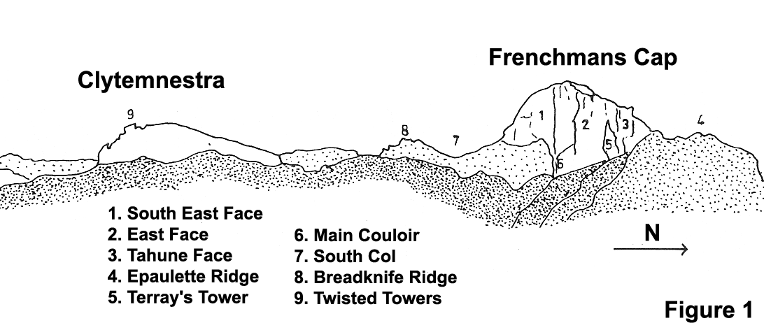
Clytemnestra
Twisted Towers and South-East Summit
★13See Figure 1. Climb down to the col below the first Twisted Tower then up the Tower (15m) returning the same way. Down the gully on west side and around to between Towers 1 and 2. Bridge up chimney between Towers (6m) and through gap on eastern side. Walk along ledge below second Tower to a crack on the R wall. Climb crack (15m, crux) then straight up to top of second Tower (12m) . Return to stance and traverse L to col between second Tower and south-east summit of Clytemnestra. Scramble to summit via easy chimney.
C. Baxter, P. Stranger, R. Williams, 17 Feb 1968.
South-West Wall
This is the far side of Frenchmans Cap from Lake Tahune.
Western Slab Route
150m13The climb commences on the first distinct smooth, sloping wall encountered when moving around the south west base of the Cap from the West Col. Slab is at least 45m in length. (Further around is a steeper, similar wall as yet unclimbed.) The LH side of the slab is bounded by a gully. Go up slab for two pitches (little if any protection) to vertical wall. Traverse leftwards along wall to short vertical crack (spike runner). Above this is a flake belay stance. Traverse L again and do two pitches up the RH nose of the gully (second one delicate). Above gully there is a hard final pitch up inside corner which commences with an overhanging chockstone.
M. Douglas, J. Fairhall, 1962.
Western Slab Route Alternate Finish
13Straight up vertical wall (after two pitches) then along a sloping terrace to the right for a short way; then straight up to top, finishing in top of gully.
I. Brown, solo, 1974.
South-West Wall Chimney
The "obvious chimney" on the southwest wall. No further details are known.
B. Allen and M. March in 1972
South-East Face
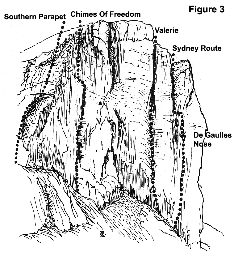
Southern Parapet
★180m10This climb goes up the south-west skyline of the South East Face (see Fig 3) . Commence from just below the South Col on its eastern side, and climb along the edge of the face until the slopes of the summit dome are reached. The main part of the climb is reached after about three rope lengths from the South Col.
R. Sykes, M Douglas. Alt. leads, Dec 1963.
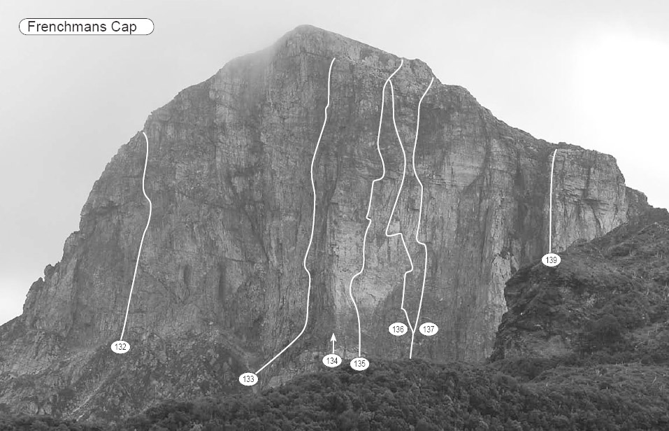
South East Face topo by Gerry Narkowicz
132. The Chimes of Freedom 270m 17
133. The Sydney Route 380m 16
134. De Gaulles Nose and The Plum line
135. The Great Flake 370m 22
136. The Lorax 385m 20
137. Conquistador 360m 20
139. Tierry le Fronde 150m 16
The Chimes of Freedom
★★★250m17J. Ewbank, J. Moore, 18 Feb 1968. FFA: (pitch 4) C. Dewhirst, D. Neilson, Jan 1970.
Valerie
390m16M4C. Dewhirst, J. Ewbank, J. Moore, P. Stranger, 16 Feb 1968.
The Natimuk Route
★340m22Simon Mentz, Steve Monks (alt) 6 Mar 1995
The Sydney Route Direct Start
★60m14Bryden Allen, Reg Williams, alt. leads, Feb 1972.
The Sydney Route
★★★380m16Bryden Allen, Jack Pettigrew, 7 Jan 1965. The ascent took about 10 hours. On two days, prior to the climb, they reconnoitered 900ft of the route. Fixed ropes were left on the lower access pitch, but not on the climb proper.
The Melbourne Variant
★370m16C Baxter, C. Dewhirst, 19 Feb 1968.
Brisbane Line
300m+18+Dayle Gilliatt, Phil Dolan, 14 Feb 1989.
The East Face
Beneath the right-hand boundary of the face is an enormous pointed gendarme (500ft+) called Terray's Tower. The old "North-East Passage" and "Fleur-De-Lis" lie to the north of the Tower. "Waterloo Road" and "Napoleon" are on the south side. "Conquistador" is in the middle of the East Face.
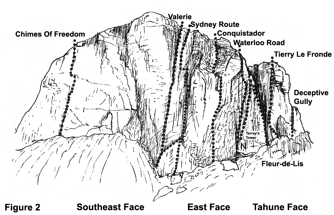
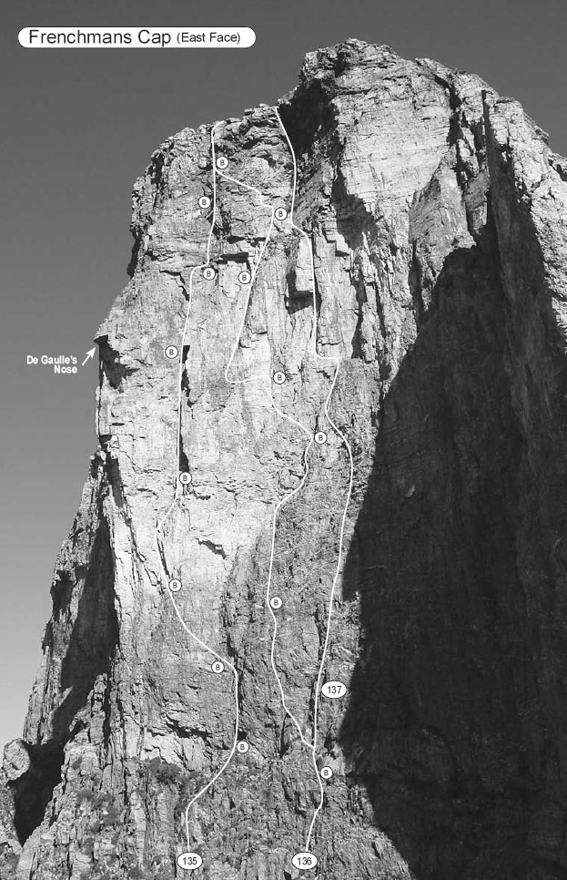
East Face topo by Gerry Narkowicz 135. The Great Flake 370m 22 136. The Lorax 385m 20 137. Conquistador 360m 20
The Plum Line
★★★390m26Adam Donoghue, Hamish Jackson & Gareth Llewellin 2020
De Gaulles Nose
★★★300m23Kim Carrigan, Mark Moorhead (var), 31 Jan 1983.
De Gaulles Nose Direct
★★★55m24Adam Donoghue, Gareth Llewellin, 1 Mar 2008.
The Great Flake
★★★370m22Kim Carrigan, Evelyn Lees, 29 Jan 1982. (ground-up with no falls!)
The Lorax
★★★385m20Peter Steane, Garn Cooper (alt), Feb 1988.
Lorax Pitch 3 Alternate - The Sucker Pitch
40 m22FA: A litany of suckers FFA: Ben Maddison? 2019
The Lorax-Conquistador Connection
55m19Pete Steane, Colin Moorhead, Jan 1997.
Conquistador
★★★360m20C. Dewhirst, D. Neilson, I. Ross, 5-6 Jan 1972. FFA David Jenkins, Rohan Hyslop (alt), Lucy Collaery, Feb 1990.
Conquistador Variants
19,M1Simon Parsons, John Fantini (var), 29 Dec 1983 .
Death and Transfiguration
130m19 M1Peter Steane, Garn Gooper (alt), 25 Dec 1994.
Waterloo Road
★310m16C. Baxter, C. Dewhirst P, Stranger, J. Veasey, 12 February 1968
Waterloo Road Direct
★★300m16R. Pauligk, P. Canning (alt), 30 Jan 1972.
Napoleon
150m15P. Canning, A. Richardson, 1972.
The Ninth of January
★★160m19Peter Steane, Garn Cooper (alt), 27 Feb 1986.
Ninth of January - Pikers Variant
25 m17M. Johnston; Je Roen 2019
Fleur-de-lis
★210m14C. Baxter, J. Fahey, 15th Feb 1968. 1a) P. Jacobs, P. Treby, 1972.
North East Passage
300m16R. Lidstone, P. Sands. Easter 1962. (The climb was started in the afternoon, so a bivouac was necessary after pitch 9.)
Tahune Face
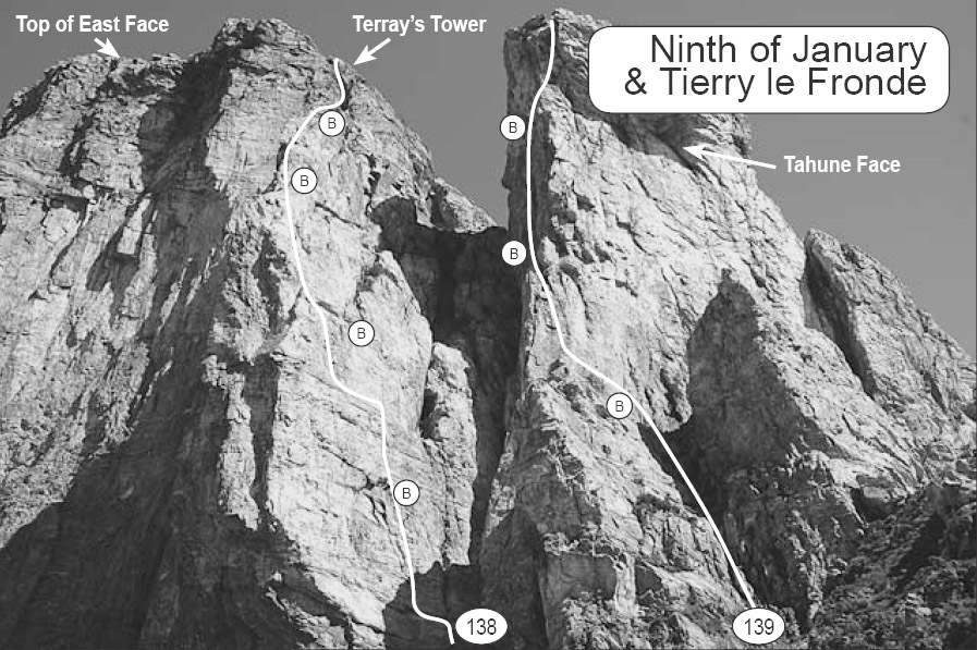
Tahune Face topo by Gerry Narkowicz 138. The Ninth of January 160m 19 139. Tierry le Fronde 150m 16
Corner Left of Tierry le Fronde
18L. Scott 1992.
Tierry le Fronde
★★★150m16P. Stranger, C. Dewhirst, (alt), 15 Feb 1968.
TLF No Pants Variant
★25m22Climbs the prominent roof crack, worth climbing for the technical movement with 130m exposure. Some loose rock and seep detract from the overall quality. Roof is visible on left side of arete above P3/4. From TLF P4 following the 6m rightwards traverse, climb direct up an easy corner gained before rounding the nose. Trend left to Hanging belay just below the roof crack. A bomber #3 protects the bouldery crux at the lip. Belay above roof and continue up well protected and easy off-width for 20m.
Michael Lehmann, Lachlan Short, Grace Bloom, 12 January 2021.
Tierry le Fronde Alternate Start
45m16Alternative start: Climb the rock buttress immediately below the first pitch. A good 45m pitch which is better than the gully start. This pitch takes the more slabby R side of the buttress (where as the direct start takes front of buttress until half height, where it too joins the slabbier face).
Dec 1975
Tierry le Fronde pitch 4 Direct Variant
★25m17Avoids the two traverses. 4a. 25m. Up overhang on arête and wall above.
Mike Law, Chris Baxter, 3 Mar 1984.
Dayle Gilliatt, Phil Dolan, 15 Feb 1989.
Bastards Benediction
★60m21M. Johnston, P. Pietruschka 2014
Cold-Steel Dawn
★★★97m18Doug Fife, Peter Steane (alt), Jan 1993.
Ground Rush
★★165m20Pete Steane, Colin Moorhead (alt), 11 Jan 1997.
Deceptive Gully
120m12J. Fairhall, M. Douglas, 1962.
Deceptive Gully Direct Start
120m14Leads from the foot of the cliff directly to pitch 3 of original route.
V. Kennedy, P. Stranger, 1968.
Eco-Facist
★80m19Arête, corner right of Deceptive Gully. 1. 35m. Up from 3m R of arête (near small King Billy pine), then L to arête. Arête until 3m below roofs, then traverse R 8m to small, sloping ledge, then up. Traversing in from DG would make grade about 15.
Peter Steane, Roxanne Wells (alt), 23 Jan 1995.
Shame of the Warrior
130m18Peter Hairsine, Richard Walton, 27 Dec 1987.
Inspector Clouseau
27m17On first main buttress 80-100m East of North Col. Start left of vegetated cracks forming a V, directly below clean, right facing corner. Up to short, clean, right facing corner on L of overhangs. Up and step left to arête.
Michael Murphy, Mark Poustie, 2 Jan 1991.
Pleasant Dreams
★45m15About 150 metres L of the North Col, viewed from the track up from Lake Tahune and slightly above the level of the Col is a lovely clean little face. To reach it, climb up the "new" walking track to the wooden signpost ("Summit-Lake Tahune") where the track steepens considerably. The start is about 25 metres toward the Col. 1. 45m. Up easily for 30 metres to an obvious one metre roof. Pass it on the L (crux). No runners after overhang.
Kim Robinson, Phil Robinson, 7 Feb 1998.
Robinsons Ramble
55m15Kim Robinson, Phil Robinson (alt), 7 Feb 1998.
25kg Of Pain For 25 Seconds Of Pleasure
12m21Overhanging rock a few metres above wooden signpost ("Summit-Lake Tahune"), approx. 25 metres left of ''Pleasant Dreams". The climb eases after the first 7-8 metres. 1. 12m. Up to the finger ledge, heel hook and go for it. Only one runner.
Kim Robinson, 7 Feb 1998.
North-West Wall
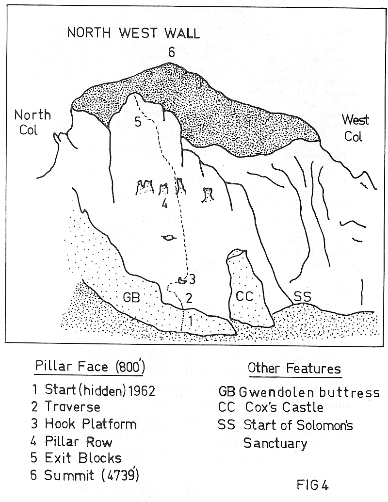
A large complex of faces, towers and buttresses. It has a sunny aspect. To reach the wall, go over the North Col and drop down towards Lake Gwendolen. Refer to figure 4.
Squeaky
★45m17Alan Williams, Vincent Day, 6 Feb 1998.
Honeysuckle Divine
33m15Start: From the top of the North Col cliff is broken on west side by corner with blank face prominent. Wall on L of blank face is split by jagged crack which breaks L at 15 metres. Climb crack for 15 metres, move L (not easy) and climb continuation of crack which is overhanging and becomes off-width near the top.
J. Nelson, J. Grelis, 29 Dec 1977.
The Pawn of Doom
25m19The flake 2m R of corner of Honeysuckle Divine. At rooflet at 10m head diagonally up L to join R-trending crack.
Colin Moorhead, Pete Steane 10 Jan 1997.
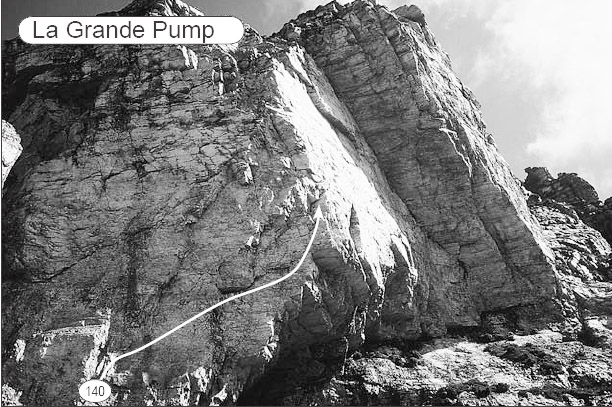
Topo by Gerry Narkowicz 140. La Grande Pump 60m 21
La Grande Pump
★★★60m21Mike Law, Chris Baxter, 4 Mar 1984.
The Enlightenment
★★48m21The grade takes into account the wad-factor. It's the prominent diagonal line on the west-facing buttress above La Grande Pump. Start: Scramble/solo up R of LGP past the prominent L - leading arête undercut by the big overhung corner. The route takes the L - leading line a couple of metres R of the arête. 1. 48m. Step down and left from the belay, then up and follow line.
Pete Steane, Colin Moorhead, 10 Jan 1997.
Gwendolen Buttress (Ridge)
210m8The first major buttress on the eastern end of the north-west wall (Fig 4). A long climb of nine pitches, and well broken with ledges and terraces. The route is separated from the Pillar Face by a deep couloir. It gives an excellent view of this face. About half-way up the buttress there is a large gendarme. This should be turned on the R. It has also been turned on the L (grade 13). The climb finishes on top of the steep, square shaped outcrop prominent from the North Col. The penultimate pitch is on a large prominent slab above arid to the R of the main spine of the buttress.
D. Cox, P. Sands, R. Hosking, Easter 1962.
Frog
50m16David Rogers, Andrew Strickland, 29 Dec 1987.
Quatre-Vingt Huit (88)
85m16David Rogers, Andrew Strickland, 31 Dec 1987.
Pillar Face
★★240m15A complex face with many alternatives. (See Figure 4). Start: The gap between the lowest sweep of the Gwendolen Buttress and the base of the Pillar Face forms a rocky ravine. (Further R is Cox's Castle.) The climb commenced from the ravine not far to the L of the "Castle". The first 30m of face forms a noticeable convex bulge (crux). Climb for 15m, then traverse horizontally across bulge to the L, finally moving up again to a broad sloping platform at the top of the bulge (conspicuous hook-shaped patch of grass on RH edge). From platform continue vertically upwards for around 150m to the overhanging blocks barricading exit. A LH swerve in the line of ascent was made when a line of weakness through exit blocks was located. Note: Halfway up face is a peculiar line of pillars on a large platform.
D Cox, M. Douglas, 1962
Pillar Face Alternative 1
★★15Across lowest platform on Gwendolen Ridge (buttress) On edge of drop into ravine leading down to Cox's Castle. Straight up.
C (B) Rathbone, P. Robinson, 1977
Pillar Face Alternative 2
★★1510m L of 1977 start. Moves R on second pitch to join 1977 route then loses it again after comer pitch. Hard exit on RH side of Pillar Ledge (loose rock).
G. Kowalik, R. Mansfield, 1978
Cox's Castle
Comment from a 2011 party: “Probably worth mentioning that getting from Le Grand Pump to Cox's Castle is a quite a way downhill and best done by staying at least 100m away from the base of the cliff in the centre of the giant gully leading to the lake, then traversing over across a few bush choked streams to make it to the bottom of the cliff. It’s probably 20 minutes (?) further walk on from Le Grand Pump.
The Nargun
★85m20Peter Steane, Doug Fife (alt), 14 Mar 1994.
Electra
★★100m17Doug Fife, Peter Steane (alt), 22 Jan 1992.
Thus Spake Zarathustra
★★110m21Pete Steane, Nicki Sunderland (var.) 15 Dec 1995.
Solomons Sanctuary
180m12A route behind the RH (west) corner of the Pillar Face, in a chasm-like gully. From the Tahune Log Book: "On southern side of North Col 50m on RH (far) side of Cox's Castle. Climb main wall and reach wide grassy terrace leading into Solomon's Sanctuary - a deep canyon cutting R into side of mountain. Four pitches on wall progressively harder, culminating in an overhanging layback crack for which pegs were necessary. Canyon Creek followed up under overhanging walls for several hundred feet to climb up 80ft waterfall and a large chockstone. Final pitch involves a traverse around the northern wall, which comes out on edge of summit plateau."
P. Sands, D. Cox, R. Hosking, Easter 1962.
Aesop's Fable
★45m18Line beginning near lowest point of clean, 40m high N facing wall L of large chimney-gull with chockstone (and below larger walls) about 20m above the "bath" in Solomons Sanctuary. Start below large, hanging flake high on wall. Up, then L edge of flake. Up R to L end of roof, then L and up to grassy ledge. Belay anchors in short crack 5m up next wall.
Peter Steane, Roxanne Wells, 24 Jan 1995.
There is a natural bathtub in the creek which flows from Solomons Sanctuary, ideal for hot, sunny days. Beside this is a 45m abseil which leads to the base of a 50m white slabby wall. Above this is a terrace beneath some bigger walls and buttresses. The wall is 100m long and has some thin lines. It is distinguished by left-slanting arches. The following climbs are on this wall.
Deviant Imagination
★50m20Follows L most weakness on wall, R of arch at L end. Near top move R to finish as for FS.
Maureen Gallagher, Russell Chudleigh, Mar 1984.
For Susan
★★50m20The prominent crack R of Dl with the bushes low down and the overhang on the R at 3m.
Chris Baxter, Maureen Gallagher, 6 Mar 1984.
(Unnamed 1)
★★50m21Line passing left end of overhang of main arch.
Russell Chudleigh, Maureen Gallagher Mar 1984
(Unnamed 2)
★50m22Spaced protection. Up wall a few metres R of previous route, climbing overhang at weakness towards its L end. Finish up line directly above.
Mike Law, Russell Chudleigh, 6 Mar 1984.
(Unnamed 3)
★45m21Between right end of R arch and waterfalls is an overhang low down. Start just L of this. Climb up, veering slightly L.
Russell Chudleigh, Maureen Gallagher, Mar 1984.
Fox n Socks
45m17Start at cairn immediately R of previous route. Veer up R on overhanging arête, then face to ledge. Face-crack to next ledge and corner.
Maureen Gallagher, Russell Chudleigh, Mar 1984.
Culture Shock
★★★160m19Peter Steane, Doug Fife (alt), 16 Feb 1992.
Strange Attractor
★★130m19Doug Fife, Peter Steane (var), 21 Jan 1992.
On the N side of the lake is a cliffline, with the most obvious feature being the laid-back expanse of Surf Slab which is approached well down to the L.
Teetering Tower Ridge
★★78m12M. Steane, P. Robinson, J. Burgess, 4 Mar 1979.
Surf Slab
★★69m12Brilliantly white and in waves. On the northern side of Gwendolen Cirque well below the Lion's Head. There is a prominent bulging pillar among the first buttresses toward the lake. The slab lies below and on the Cap side of this. It is in two sections broken at 2/5 height by a grassy terrace. The lower section is easier. A cairn (1974) marks the start in the centre of the slab. Excellent climbing on small secure holds in great shiny white rock. Climb straight above the cairn veering in places to the grassy terrace above the second slab and walk off. Towards the top of the second slab is a slight flake crack. Up thin crack (crux).
I. Brown, M. Hutton (solo), 1974.
Board Shorts, Bored Shorts
16Little is known about this route, but it appears to be at least as good as Surf Slab. Start in the middle of the foot of the slab climbed by Surf Slab. Take a direct line slab followed by a steeper section.
Maureen Gallagher, Russell Chudleigh, Mar 1984.
Breakfast of Champions
★30m17/18Magnificently overhanging. More awkward than technical. Sustained. Start: The obvious big overhanging line under the nose of the Lions Head, seen clearly when approaching the North Col from Tahune. Scramble up from the North Col across and up into the big cave. Good nut belay on L, out of stonefall line. 1. 30m. Up to the big triangular block. Chimney out under it and up on to loose blocks. Bridge up to obvious traverse R . Across on shattered rock then hand traverse line to sharp nose. Up the line to top. (Double rope useful.)
I. Brown, P. Blunt, 22 Feb 1979.
Cyrano
40m11Slab split by crack 50m north of North Col. Traverse R above this on slabby ledges. Up seam through bulge and overlap. Traverse R to arête. Up corner to Lions Head.
David Moten, Chris Holley, 8 Feb 1994.
The Eastern Arm
Sharlands Peak
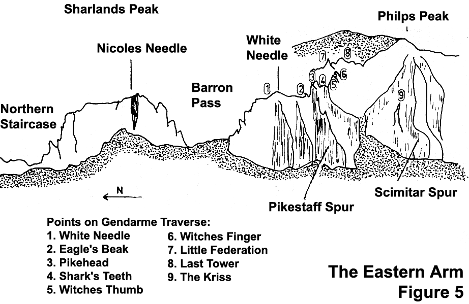
The peak can be divided into two features consisting of huge 150m high pillars. From south to north these are Nicoles Needle and the Northern Pillar (Figure 5). Some magnificent though difficult routes are still waiting here.
Northern Staircase
180m10M. Douglas, J. Fairhall, A. Keller, 26 Dee 1967 (varied leads). Varian R. Mansfield, G. Kowalik, 1979.
White Needle - Philps Peak Area
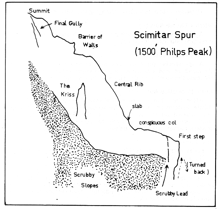
The two outstanding features here are the high Gendarme Ridge and Scimitar Spur. The latter is approximately 450m in length and falls from the summit of Philp's Peak in a S.W. direction toward the Livingstone Valley (see Fig 5). It involves climbing of all grades. There are some very substantial cliffs falling away on its N.E. side. About halfway up the spur on this side there is a large (50m) gendarme called the Kriss. The best way of reaching the spur is to go over the summit of the White Needle (described below) and then to drop down towards the valley in the vicinity of the "Eagle's Beak". It can also be reached by going around the western base of the White Needle from the Barron Pass. However this involves a tedious scrub bash and is relatively slow. On the other hand, there is no exposure. The high route is mildly exposed.
The Gendarme Ridge
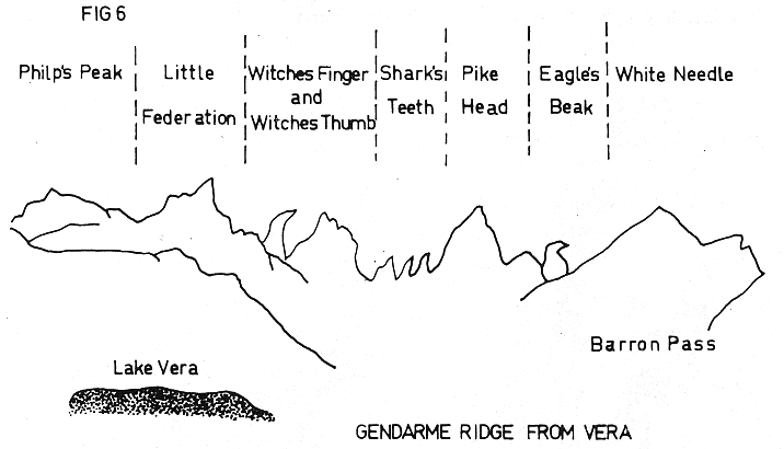
★★10An enjoyable and straightforward high level traverse, the ridge being at about 4000 feet. Refer to Figs 5 and 6. White Needle 6. From Barron Pass scramble up through scrub to a steep wall with an overhang above it. Continue R of this through a gap and climb short wall on L to gain ridge. Straight up ridge for three ropelengths leads to a knife-edge ridge (4) and summit of White Needle. Alternatively, keeping L of the ridge from Barron Pass, there is a scrub clutching scramble to the top. There is said to be a nice rock climb up the western side of the White Needle, done by J. Peterson and B. Eklund, probably in 1961. Eagle's Beak 12m 6. The foot of this gendarme is reached by a walk over some low towers of no consequence from the White Needle. The hooked summit of the Eagle's Beak is clearly visible from the northern end of Lake Vera. Pikehead 30m 8. After the Eagle's Beak, several gendarmes of lesser interest are climbed. These are followed by a relatively large tower, pikehead. There is an unclimbed spur, Pikestaff Spur, dropping away to the west of this tower. There are two prominent gendarmes on this spur. Shark's Teeth - Three small towers with overhanging summits. Easy. Witch's Thumb 18m 8. A high gendarme providing a fine climb on small holds. The west face falls away for 30m. Witch's Finger 18m 8. A spectacular piece of rock also clearly visible from Vera. Its northern end overhangs in a grotesque curve. Ascend it by climbing the southern side. The west face is 50m plus. Little Federation 18m 10. After the "Finger" there are several small steps; then the 'Little Federation' which is the second last tower of the ridge and situated on an eastern curve in the Gendarme Ridge. The south face drops away vertically for 60m. Ascend it via the western corner. Abseil off summit. Last Tower. Easily climbed on its S.W. side. Then scramble up to summit of Philp's Peak. Time from Barron Pass to Philp's Peak: about six hours. The return trip can be made in a little more than one hour by using the western slopes below the gendarmes, then cutting up over the summit of White Needle.
First traverse P. Sands and M. Douglas, 7 Jan 1966.
Scimitar Spur
★500m12Location: Philp's Peak. The main buttress running from summit of Philp's Peak towards Livingstone Valley in south-westerly direction. (Refer Fig 5) Access: From Barron Pass, over summit of White Needle; then drop down into valley from a point near the Eagle's Beak. Definite identification of the spur can be made by distinguishing the "Kriss" - a 50m gendarme on the north side of the spur - the Kriss is often difficult to pick up as its outline seems to camouflage itself in the mass of the spur behind it. 1. Attempt at direct line up crest of first step failed after 30m. 1967. 2. Up scrubby lead on north-west side of first step - this lead (30m) is fairly prominent and is just up from crest of the step. Then up vertical scrubby chimney just to the right. (30m) Continue up gully until top of first step of spur is reached. 3. Scramble and climb for about 10m (grade 6-8), crossing conspicuous semi-circular col on the way. Arrive at slab below central rib of spur. 4. Traverse across slab and around corner to L. 30m. 5. Up wall above (exposed) to gain crest of spur (30m). Nut runner. 6. Continue up crest for 30m to the head of the rib. 7. Scramble for a few rope lengths until halted by a barrier of walls. The wall appears to be difficult but can in fact be climbed easily (24m). 8. Scramble to next wall (24m). This wall can be avoided by walking around to R. 9. Final 60m overhanging wall to L of true line of spur was not climbed. Instead scrambled for 100m up gully to end climb. (Once on the spur, there is no simple escape.)
M. Douglas, J. Fairhall, A. Keller, 25 Dec 1967.
The Kriss
45mClimbed from the col between it and the N.E. walls of Scimitar Spur. (Straightforward.)
J. Ewbank, A. Keller