
Mount Roland
 45 min uphill
 All day sun
 Conglomerate, up to 420m
Acknowledgement
by Tony McKenny, with additional info from Matt Perchard and Andrew Bissett, originally published in Craglets 6.
Introduction
Mt Roland dominates the skyline of the approaches to the North West, but has received relatively little attention from passing climbers. Some shorter routes were made in the mid seventies but it wasn’t until 1977 that the first major route was made with the pioneering of Rysavy Ridge by a group of North West climbers. Over the next three years, a number of new climbs were added but since then there has been only a handful more recorded. There are still many acres of untouched rock to be explored, but most climbers seem content to repeat the classic Rysavy Ridge. The Ridge is a long day out and can take up to six hours, with another couple for the descent: many climbers seem to underestimate the time needed and descents in the dark are becoming common. The record for the longest ascent/descent seems to be 23 hours. Take a torch!
There are no bolts to date on the cliffs and climbers are asked to respect this “no bolt” status.
Access
Access to the mountain is via the Sheffield-Gowrie Park – Cradle Mountain Road (C136). 2.2km west of the Claude Road village, heading towards Gowrie Park and Cradle Mountain, turn L up Rysavy Road (signpost for the Silver Ridge Retreat). Veer L at the top and continue to the farm.
Steve Brown, one of the first ascensionists of the Ridge, now owns the farm and climbers are asked to phone him first for permission to cross his paddocks to the base of the cliffs (0408441945). Climbers are asked to park outside the farm gates, and to restrict their climbing, if at all possible, to between 8am and 8pm, to minimise disruption to the people living in the farm.
Basic accommodation is now available for climbers and like-minded people in the Mt Roland Bothy at the base of the mountain, directly below the famous Ridge.
Gas and electric cooking. Fridge. Microwave. Heater. Shower. One double bed. One couch. Bring own sleeping bags/doona/pillow. $15 pp a night.
Contact Steve at 102 Rysavy Road, or phone 0408 441945 or email steviebintas@hotmail.com.
Alternatively, bush camping is available a couple of kilometres further along Claude Road on the L at the O'Neill's Picnic Area or you can try the Budget Backpackers (https://www.gowriepark.com.au/budget-backpacker-rooms), about another 500m down the road in the old hydro township, or what is left of it.
Walk up a track past the L of the farmhouse and follow the fence line up and across the paddocks to the R corner, past the fields, and up to a large cairn of rocks. A line of red tape and the occasional small cairn mark a path from here up through the bush to the bottom of Rysavy Ridge. Time to the cliff from the farm is about three quarters of an hour (about 300m in height gain).
Crag Steward
Rock climbers please contact the Cliff Steward (mtroland@climbersclubtas.org.au) if you have any queries or concerns regarding social or environmental impacts of rock climbing at this crag. Do not email regarding general travel, seasonal advice, or lost property - this is not the Steward’s role. If you have important safety information to communicate (e.g. risks due to recent and large rock falls) please also consider updates on thesarvo forum, facebook group and/or online guidebooks as appropriate. Please copy in cct@climbersclubtas.org.au if you feel you have a high level concern which may imminently impact the crag or climbing community.
Non-climbers, other users, land managers: please also contact cct@climbersclubtas.org.au if you have important climbing related queries at this location.
GPS
Warning. A severe weather event occurred in the Mt Roland environs in 2022. The extreme winds associated with it resulted in many trees falling across the access track to the cliffs and in the descent gully. The track has been cleared and made safer by local climbers, but more work will probably be needed.
Caution
Given the height and exposed location of the cliffs, climbers should be prepared for mountain weather and variable conditions at any time of the year. The rock is conglomerate, and some is loose and friable: there have been at least 3 falls recently (2024), one over 15m long, all caused by breaking holds. Fortunately no one has been seriously hurt, but solo/simul climbers be warned! A helmet is also strongly recommended. It is also strongly recommended to place protection when available, and expect the occasional runout, particularly on easier walls/slabs.
The polished aggregate that makes up the rock can also be incredibly slippery when wet. Note there is no water in the area of the cliff in summer, so come prepared.
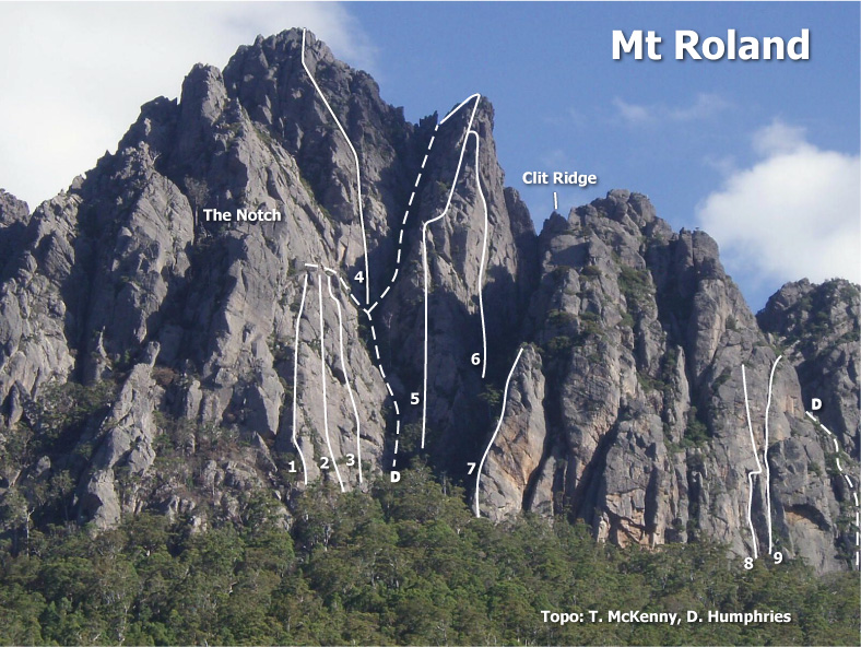
The track to the cliff arrives in the middle of the face at the base of Rysavy Ridge. The wall to the left is Jubilee wall while further left is the Notch. The climbs are listed from L to R.
Brown Buttress
Nic Deka and Neale Smith began exploring this area in early 2022, the plan being to open up alternative routes to complement the well established Rysavy Ridge. It is a complex and arduous process working new routes on Roland but the routes now established are well worth doing if you are looking for more than a day (and night for some!) of adventure in a spectacular location or shorter alternatives to Rysavy Ridge.
Access to this buttress is a little complex but an access route has been established. This involves a roped scramble, a walk through a couple of short sections of scrub (track cut) and a series of easy slabs (unroped).
To locate access route follow track up mountain as per usual. Identify the slabby walls with the routes Jubilee and Slab Crack - these are approximately 70m prior to the base of Rysavy Ridge out left. Walk north under base of slabby walls to a large boulder (cave underneath). Scramble on top of boulder to comfortable ledge area. There is a large gum tree at front left of ledge. The access route starts here. It is best to rope up for first section of approach. Climb initial 3m step to a ledge with small gum tree. Pull on to slab above and move left. Continue left and up to gum tree with sling in situ for belay. From here continue unroped following track, tapes and slabs to base of cliff (another gum tree at base). 3 routes start from this general area. 1. A Brown Study (14). 2. Brownian Motion (16 or 18 depending on start) and 3. Brown's Cows (15-16).
A Brown Study commences 10 or so metres L of tree - you will find an aluminium tag on an old wire at base of ABS. Brownian Motion heads up groove/crack above tree and Browns Cows starts up gully into corner between the above routes.
The buttress is themed in honour of Steve Brown who owns the property and is generous in allowing access through his land to the mountain. Steve also taught Nic Deka and Neale the finer points of rock climbing in 1977/78 whilst we were in years 11/12. That knowledge and experience has stood us in good stead for 4.5 decades!
There is now basic accommodation available on Steve Brown's property - contact Steve via number listed for access. There is also a campground at Gowrie Park, just up the road a bit.
Nic Deka and Neale Smith - 19th March 2022
Neale Smith and Nic Deka - 23 November 2023
Neale Smith and Nic Deka - 8th April 2022
The Notch
It is worth noting that the following 2 routes are vaguely described and are of uncertain location!! The Roof; Fortunes Change.
The Roof
45m15Climb the crack that splits the massive block on the L, finishing up a short chimney above. A further scramble was later added by F. Dutton, adding another 25m to the climb. Descend by abseil then traverse to the notch.
T. McKenny, G. Marshall 1978
The Notch is the saddle in the ridge up to the L at the top of Jubilee wall, below an impressive roof.
Below The Roof and to the left of Fortunes Change is a gully that can be used to descend from Fortunes Change or ascend to the summit ridge - it involves scrambling and vegetation.
Fortunes Change
80m14Left of Kestrel is a ridge with a face on the R side. Climb the obvious crack.
S. Brown, T. McKenny 1980
Jubilee Wall
Jubilee wall has three routes and is the wall to the left of the ascent track. All three routes finish above steep slabs which lead back down R towards the Descent Gully. The easiest descent, however, is to climb back up towards the Notch, moving across the top of the slabs before then descending back R. Abseil to the solitary gum and so down to the main Rysavy Ridge Descent Gully.
Left of Slab Crack is an edge bordering the deep gully. The climb takes this and the steep upper sections.
F.Dutton, J.Richardson, Mar 1977.
S.Brown, R.Hamilton, 1977.
T.McKenny, S.Brown, Aug 1977.
Central Buttress
This area is in fact a collection of buttresses above the last climbs and to the L of the main Descent Gully. The first route was an attempt to climb the massive boiler plate slabs on the wall to the east of the Rysavy Ridge Descent Gully.
The Wandering Jew
140m15Climb the descent route from the above routes, past the solitary gum, up the scrub, and to the crack up the slab. Traverse left to belay on the wall just right of The Roof. Avoid the crack and continue right across the wall, to gain the slab and finish – a tortuous but apparently worthwhile ascent. Descend as per that route.
J.Richardson, R.Hamilton,1978.
The next climb takes a line high up on the Central Buttress, on the wall to the L of the top section of Rysavy Ridge.
P. Robinson, B. Rathbone, L. Linsell, 22 Oct 1978.
Rysavy Area
A true mountaineering route of classic proportions, with tremendous rock scenery and an awesome atmosphere. Among the best of its grade in the state. The climb is fairly straight forward, generally following the line of least resistance up the ridge unless you want to make your own, harder variation (which many have, sometimes inadvertently). Having said this, it is not a climb to take lightly. To escape from the top 100m or so of the ridge is not easy, the exposure is tremendous and the rock can be very slippery if it rains...and the gear could be considered sparse if grade 12 is around your limit. At the top, a classic “cheval” joins the ridge to the cliff, and then an abseil can be made down the gully to the left. Look for the slings other parties have left behind (old tat accumulates very fast so please take a knife to remove old slings, and be prepared to replace them - you will need maybe 6-7 long ones) to guide you: six or seven abseils should see you back at the bottom. The climb takes most teams at least six hours so leave plenty of time for the descent. Have fun.
S. Brown, T. McKenny, J. Richardson, J. Wood, Feb 1977.
Two routes have been made on the steep wall that forms the RH side of the Ridge.
Second Encounter
150m17Climb up the RH gully to below a steep, fairly obvious crack. The route takes this to eventually join the Ridge.
R. Mansfield, R. Clements, 1978.
R. Clements, R. Firth and R. Mansfiled, 1978.
Clit Ridge
Tucked in between Rysavy Ridge and West Buttress is a subsidiary ridge that was subject to a mass assault by various North West climbers. The general opinion of the group as to its worth is not printable.
West Buttress
First Taste
80m18(16M0)The first route made on the West Buttress is in fact on the large wall 70m up the RH side of the gully to the R of the Ridge. The climb starts at the foot of a shallow groove that curves up to a square cut overhang. A tension traverse was made from the overhang to gain the next crack to the L which is followed to a tree belay. Climb the ascending ledge to the R and finish up the wide crack in the wall above. Descend the wide ledge to the L and abseil back to the gully floor.
R. Mansfield, D. Buckingham 1978. FFA: N. Smith, M. Hewitt.
G. Kowalik, R. Mansfield and M. Tillema, 1979
West Buttress Face
Several climbs have been made on the main face to the R of the Ridge. Fight round the base of the crag through the scrub past large faces and overhangs till you reach the massive “half moon” overhangs with gentle angled slabs below them. To the L of these slabs is a rib and round that is a long chimney line, Orrifi, the most obvious feature from a distance in this area of the crag.
This climb takes a line to the L of Orrifi and starts from the same place in the scrub. Head up towards an open groove which is followed to a traverse R onto an exposed stance. From here, climb the wall above and traverse R to belay as for Orrifi above the first chockstone. Move back onto the wall and finish steeply up the crack. Walk off and scramble up to the R above the finish of Orrifi.
N. Deka, R. Hamilton, 1978.
A most unusual route. Climb up to the base of the chimney and then chimney up to below a massive chockstone. From here the route goes underground. Larger people will have to force an alternative round the outside. A speleological exit is made over the chock and a belay taken. The climb continues with a superb chimney and another improbable squirm under a chockstone to finish. The chimney suddenly finishes here but it is probably possible to continue up the slabs above and to the L. Descent down and to the R.
S. Brown, T. McKenny, 1978.
Mexican Wave
60m18N. Deka and N. Smith 1985
To descend from both climbs, traverse round the cliff to the R and abseil down the slabs to the gully floor.
Forestry Wall
The first recorded climbs were made here in 1976 on a small wall in the middle of the great sweep of the main Mt Roland face. Navigation is complex here - there are just so many buttresses and walls to choose from, you may end up on a new route anyway! To access Forestry Wall, as you come from Sheffield, turn L in the hamlet of Claude Road and drive up to the end of Wildlife Road. Walk straight up to the wall, located above the main tree line.
Assessor Wall
20m11A line on the LH end of the wall. Climb the crack, past two bulges.
M. Chin, R. Hamilton, 1976.
Bird's Crack
20m8A short pitch but apparently popular on the day! An obvious crack, opposite to the Wall.
R.("Bird") Hamilton, B. (Fred) Dutton, S. Brown, L. Dutton, M. Norris, G. Marshall, 1976
Warm-Up
75m11S. Brown, F. Dutton, 1976.